Historical Archives
The first organized digital collection of Port Aransas historical photographs. Sourced from government archives, public libraries, and institutional collections.
All images are public domain. This collection grows with every research session. If you have historical photos of Port Aransas, we'd love to include them.
31
Photos
9
Decades
94
Topics
Through the Decades
Port Aransas in Pictures
1850s
1 photoView at Portal to Texas History / Star of the Republic Museum
1853 · Portal to Texas History / Star of the Republic Museum
Reconnaissance of Aransas Pass, 1853
1853 · Portal to Texas History / Star of the Republic Museum
U.S. Coast Survey navigation chart of Aransas Pass — the channel that connects the Gulf of Mexico to Corpus Christi Bay. Drawn under Superintendent A.D. Bache. This is what the Mercers were piloting ships through when Robert Ainsworth Mercer began his logs in 1866.
1860s
1 photo
1863 · National Archives (NARA) via Wikimedia Commons
Civil War Map — Union Capture of Aransas Pass, 1863
1863 · National Archives (NARA) via Wikimedia Commons
Map showing the position of the bar and Confederate batteries at Aransas Pass, each mounting a 20-pound Parrott gun. Union forces under Major General Banks took the position on November 17, 1863. Federal troops blockaded the pass from 1862-1866 — the same blockade that drove the Mercer family inland.
1900s
2 photos
c. 1900-1905 · UTSA Libraries Special Collections
Off to the Fishing Grounds — Tarpon, Texas
c. 1900-1905 · UTSA Libraries Special Collections
View from a steam-driven launch looking back toward a string of rowboats. The town of Tarpon (later Port Aransas) is visible in the distance — the large building is the Tarpon Inn. This is Port Aransas at the height of the Tarpon Era, when the town was literally named after the fish.

c. 1908 · UTSA Libraries Special Collections
Dave Gallagher with Shark, Port Aransas
c. 1908 · UTSA Libraries Special Collections
Dave Gallagher (right) poses with a shark he caught near Port Aransas, photographed by Atlee B. Ayres around 1908. Shark fishing was common alongside tarpon — the Gulf waters off Mustang Island held everything.
1910s
5 photosView at Library of Congress
c. 1911 · Library of Congress
Panoramic View of Aransas Pass, Texas
c. 1911 · Library of Congress
A sweeping panoramic photograph of the town of Aransas Pass, Texas — the mainland gateway to Port Aransas across the channel. This was the era when the Aransas Harbor Terminal Railway was running trains to Harbor Island and the first ferry operators were establishing crossings.

September 20, 1919 · National Archives (NARA) / Bureau of Lighthouses
Aransas Pass Light Station After the 1919 Hurricane
September 20, 1919 · National Archives (NARA) / Bureau of Lighthouses
Foundations of the cistern and old dwelling at the Aransas Pass Light Station, photographed September 20, 1919 — weeks after the devastating hurricane that destroyed most of Port Aransas. The 1919 storm brought a 12-to-15-foot surge that wiped out the original Farley Boat Works and depopulated the island.

c. 1911-1924 · University of Houston Libraries, Special Collections
The Tarpon Inn, Port Aransas
c. 1911-1924 · University of Houston Libraries, Special Collections
Historic photograph of the Tarpon Inn with early motorized vehicles parked in front. Photographed by J. E. Cotter between 1911 and 1924. The Tarpon Inn has been the social hub of Port Aransas since 1886 — 7,000+ signed tarpon scales line the lobby walls.

c. 1910 · UTSA Libraries Special Collections
Robert M. Ayres Fishing near Port Aransas
c. 1910 · UTSA Libraries Special Collections
Robert M. Ayres lands a fish from a rowboat near Port Aransas, photographed by Atlee B. Ayres around 1910. This is fishing in Port Aransas before motorized boats — a rowboat, a rod, and the Gulf.

September 14, 1919 · Library of Congress
Corpus Christi After the 1919 Hurricane
September 14, 1919 · Library of Congress
Panoramic photograph of the devastation in Corpus Christi on September 14, 1919 — the same storm that destroyed the original Farley Boat Works and brought a 12-to-15-foot surge that wiped out most of Port Aransas. This storm depopulated the island.
1930s
3 photos
February 1939 · Library of Congress / FSA-OWI Collection
Sign on Causeway from Port Aransas to Aransas Pass
February 1939 · Library of Congress / FSA-OWI Collection
A road sign on the causeway connecting Port Aransas to Aransas Pass, photographed by Russell Lee for the Farm Security Administration in February 1939. Two years after FDR caught his tarpon here, this is what the crossing looked like — wooden planks over railroad trestles.

February 1939 · Library of Congress / FSA-OWI Collection
Fish House, Port Aransas, 1939
February 1939 · Library of Congress / FSA-OWI Collection
A fish house in Port Aransas, photographed by Russell Lee for the Farm Security Administration in February 1939. Port Aransas was a working fishing village — fish houses like this processed the day's catch for market and local sale.

February 1939 · Library of Congress / FSA-OWI Collection
Fire Fighting Equipment on Ferry, Port Aransas, 1939
February 1939 · Library of Congress / FSA-OWI Collection
Fire fighting equipment and capstan on the Port Aransas ferry, photographed by Russell Lee for the Farm Security Administration in February 1939. The ferry system was still privately operated at this time — Nueces County wouldn't take over until 1951.
1970s
3 photos
August 1970 · NOAA Photo Library / Coast and Geodetic Survey
Boats Grounded by Hurricane Celia, 1970
August 1970 · NOAA Photo Library / Coast and Geodetic Survey
Boats blown ashore by Hurricane Celia at Aransas Pass, August 1970. Celia made landfall with 161 mph gusts and destroyed 75% of Port Aransas. The fishing fleet was scattered across the island. Pearl Beer donated water when the town's supply was contaminated.

August 1970 · National Weather Service / NOAA
Church Damage from Hurricane Celia, 1970
August 1970 · National Weather Service / NOAA
Damage to a church near Corpus Christi caused by Hurricane Celia's 161 mph gusts. The storm destroyed 75% of Port Aransas. The island rebuilt — as it always does.

November 1972 · National Archives / EPA DOCUMERICA
Abandoned Lighthouse, Corpus Christi Area, 1972
November 1972 · National Archives / EPA DOCUMERICA
An abandoned lighthouse near Corpus Christi, photographed as part of the EPA's DOCUMERICA project in November 1972 by Marc St. Gil. Texas once had a network of lighthouses guiding ships along the Gulf Coast — most were decommissioned as modern navigation technology replaced them.
1980s
1 photoView at Texas Historical Commission / Portal to Texas History
May 1, 1981 · Texas Historical Commission / Portal to Texas History
Aransas Pass Light Station, 1981
May 1, 1981 · Texas Historical Commission / Portal to Texas History
Color photograph of the Aransas Pass Light Station (Lydia Ann Lighthouse) taken in May 1981, before H-E-B's Charles Butt purchased and relit it in 1988. The lighthouse was deactivated by the Coast Guard in 1952 and sat dark for 36 years.
2000s
5 photos
July 5, 2005 · Wikimedia Commons
Lydia Ann Lighthouse — Aerial View
July 5, 2005 · Wikimedia Commons
Aerial photograph of the Lydia Ann Lighthouse from 300 feet, showing its position on the Lydia Ann Channel. The lighthouse has guided mariners through Aransas Pass since 1857 — the only Texas lighthouse with a live-in keeper.

2005 · Wikimedia Commons
Ferry Landing, Port Aransas, 2005
2005 · Wikimedia Commons
The TxDOT ferry landing at Port Aransas. The free 24/7 ferry system has operated since 1968 under state control, moving millions of vehicles per year across the Corpus Christi Ship Channel.

June 22, 2007 · Wikimedia Commons / Larry D. Moore
UTMSI Campus, Port Aransas, 2007
June 22, 2007 · Wikimedia Commons / Larry D. Moore
The University of Texas Marine Science Institute campus in Port Aransas, landscaped with palms along the ship channel. Founded in 1941 after a zoologist built a one-room shack on a dock to investigate a fish kill — now a 72-acre research campus.

August 20, 2008 · Wikimedia Commons / Jon Lebkowsky
Lydia Ann Lighthouse Close-up, 2008
August 20, 2008 · Wikimedia Commons / Jon Lebkowsky
The Lydia Ann Channel Lighthouse at Aransas Pass, photographed from the water in 2008. Twenty years after Charles Butt purchased and relit it, the lighthouse continues to operate as the only Texas lighthouse with a live-in keeper.

June 22, 2007 · Wikimedia Commons / Larry D. Moore
The Tarpon Inn, 2007
June 22, 2007 · Wikimedia Commons / Larry D. Moore
The Tarpon Inn in 2007, listed on the National Register of Historic Places. Built in 1886, rebuilt after the 1919 hurricane, survived Celia and Harvey. FDR's signed tarpon scale is still in the lobby.
2010s
10 photos
November 17, 2010 · NOAA Photo Library / William B. Folsom
Fishermen and Yachts, Port Aransas Harbor
November 17, 2010 · NOAA Photo Library / William B. Folsom
Small-scale fishermen and yachtsmen sharing the Port Aransas harbor. The working waterfront and the recreational marina have coexisted here for over a century.

June 19, 2010 · Wikimedia Commons / Liveon001
Port Aransas Boat Dock, 2010
June 19, 2010 · Wikimedia Commons / Liveon001
The boat dock at Port Aransas — where charter captains, commercial fishermen, and recreational boaters share the same waterfront. The working harbor is the heartbeat of the island.

January 28, 2012 · Wikimedia Commons / Tiffany LeMaistre
Two Ferries Crossing, Port Aransas, 2012
January 28, 2012 · Wikimedia Commons / Tiffany LeMaistre
Two TxDOT ferries crossing the Corpus Christi Ship Channel simultaneously. The free ferry system runs 24/7 with up to 6 vessels at peak times, moving millions of vehicles per year.

July 4, 2013 · Wikimedia Commons / Spheroidite
South Jetty, Port Aransas, 2013
July 4, 2013 · Wikimedia Commons / Spheroidite
Looking out toward the Gulf of Mexico from the South Jetty in Port Aransas. The granite jetties were built in the 1890s-1910s to stabilize Aransas Pass, using blocks transported by the Aransas Harbor Terminal Railway from Central Texas.

June 19, 2010 · Wikimedia Commons / Liveon001
Mustang Island Beach
June 19, 2010 · Wikimedia Commons / Liveon001
The beach at Mustang Island State Park — miles of undeveloped Gulf shoreline on the same barrier island as Port Aransas. The island has drawn visitors since the Karankawa fished these waters 5,000 years ago.
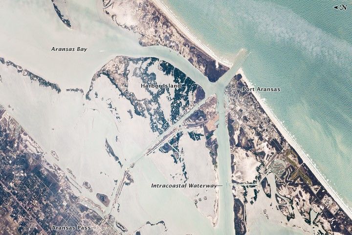
February 21, 2014 · NASA Earth Observatory / ISS
Port Aransas from Space — ISS, 2014
February 21, 2014 · NASA Earth Observatory / ISS
Port Aransas and the Intracoastal Waterway photographed from the International Space Station on February 21, 2014. The barrier island, Aransas Pass channel, and Corpus Christi Bay are all visible. The ferry crossing is the thin gap between Mustang Island and Harbor Island.
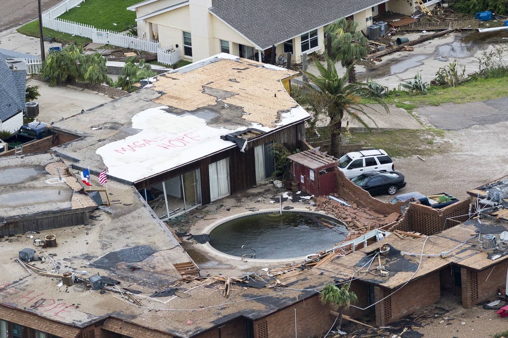
August 28, 2017 · DVIDS / Texas Military Department
Hurricane Harvey — Port Aransas Coastline Damage, 2017
August 28, 2017 · DVIDS / Texas Military Department
Aerial photograph of Hurricane Harvey damage along the Port Aransas coastline, taken August 28, 2017 — three days after the Category 4 storm made landfall. Harvey destroyed an estimated 70% of Port Aransas buildings and caused roughly $1 billion in damage.
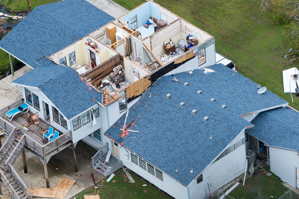
August 28, 2017 · DVIDS / Texas Military Department
Hurricane Harvey — Port Aransas Aerial, 2017
August 28, 2017 · DVIDS / Texas Military Department
Aerial view of Port Aransas after Hurricane Harvey. 100% of Port Aransas businesses were damaged. The building department issued 5,539 permits in the 10 months after the storm — more than three times the normal rate.
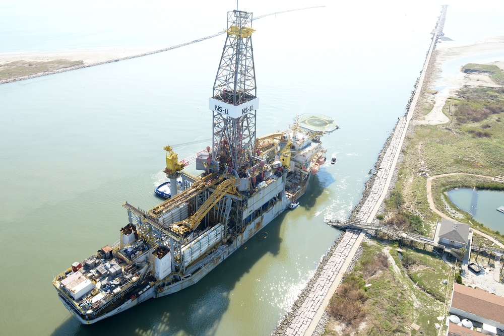
August 31, 2017 · DVIDS / U.S. Coast Guard
Drill Ship Aground After Harvey, 2017
August 31, 2017 · DVIDS / U.S. Coast Guard
A drill ship run aground near the Port of Corpus Christi after Hurricane Harvey. The Corpus Christi Ship Channel handles billions of dollars in energy exports — Harvey's surge scattered ships across the waterway.
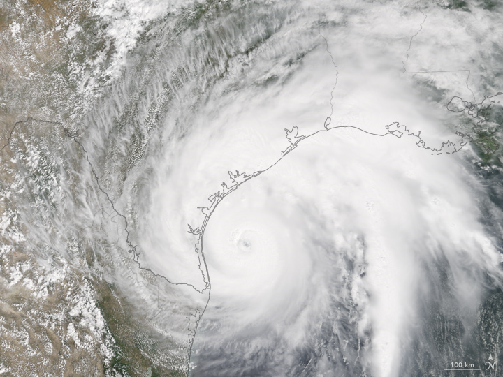
August 25, 2017 · NASA Earth Observatory
Hurricane Harvey Approaches Texas — NASA, 2017
August 25, 2017 · NASA Earth Observatory
NASA MODIS satellite image of Hurricane Harvey approaching the Texas coast on August 25, 2017. The storm made landfall near Port Aransas as a Category 4 hurricane with 130 mph winds.
About This Collection
This is the first attempt to organize Port Aransas historical photographs into a single, publicly accessible digital collection. Every image is sourced from government archives, university libraries, and public domain collections.
Port Aransas has an extraordinary photographic record — the Port Aransas Museum alone holds nearly 40,000 historical images, most of which have never been digitized for public access. This archive is a starting point, not an endpoint.
If you have historical photographs of Port Aransas — family photos, inherited collections, or institutional materials — we would love to help preserve and share them. Contact us at hello@theportalocal.com.
The Stories Behind the Photos
Every photo in this collection connects to a story. Read the history that shaped Port Aransas.